Looking for design inspiration? Browse our curated collections!

 Printed By G. Nicol And T. Cadell For The 1785 Edition Of Captain James Cook And James King’s T-Shirt featuring the photograph 1785 Cook Bligh Map of Hawaii by Paul Fearn")

The watermark at the lower right corner of the image will not appear on the final product.

by Paul Fearn
$28.00
Design Location
Color
Image Size
Product Details
Our Bella / Canvas t-shirts are made from a 50% cotton / 50% polyester blend and are available in five different sizes. All t-shirts are machine washable.
Design Details
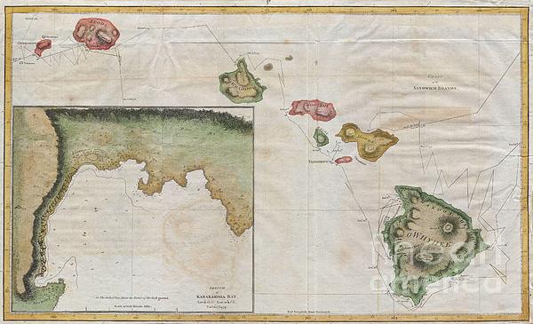
Offered here is an extraordinary and important map of the Hawaiian Islands (Sandwich Islands) printed by G. Nicol and T. Cadell for the 1785 edition... more
Ships Within
1 - 2 business days
Average Rating (4.34 Stars):


Sherrie Yarbro
April 26th, 2024

We loved the T- shirt but needed the print for a cover for my husbands prosthetic leg. He was in an awful accident a year and lost a leg as a result. He is a Beatle Fanatic and we had to put them on his new leg. Thanks for the awesome art and it was the perfect size.
Suzanne Hale
April 19th, 2024

Very original shirt, lots of compliments- great fit.
Dana Frederickson
April 19th, 2024

This is an excellent t-shirt! An excellent view of an SAS Connect Airbus A320-251N coming in for a landing! I especially wanted to buy this t-shirt because I am of Swedish descent! Excellent photography and artwork!
Dana Frederickson
April 19th, 2024

This is an excellent t-shirt! An excellent view of a P I A Boeing 777 coming in for a landing! The t-shirt came out great! Excellent photography and artwork!
Dean Will
April 18th, 2024

Very pleased with the item!! But wrong color.
Simon Brown
April 13th, 2024

Great but Jaws fans saying it's spelt Pippit
Offered here is an extraordinary and important map of the Hawaiian Islands (Sandwich Islands) printed by G. Nicol and T. Cadell for the 1785 edition of Captain James Cook and James King’s, A Voyage to the Pacific Ocean…in the Years 1776, 1777, 1778, 1779, and 1780. Some claim this map was drawn by William Bligh, of Mutiny on the Bounty fame, while he was stationed as midshipman on Cook’s fateful third voyage to the South Pacific. Others claim that this map was drawn by Henry Roberts – the Hydrographer of Cook’s third expedition. The text of the Third Voyage credits Roberts, however, the British Hydrographical Office copy of the Official Account includes Bligh's journal where he claims to have drawn the maps. In the lower left there is a large inset of Karakakooa Bay and the villages there. It was here that Cook was killed by angry Hawaiians. This map represents a seminal moment in Hawaii cartography and is the basis upon which all subsequent maps of Hawaii were drawn.
My passion is Photography and Aviation or is that Aviation and Photography ! I hope you enjoy my photographs.

Our return policy is very simple:
If you're not happy with a purchase that you made on FineArtAmerica.com, for any reason, you can return it to us within 30 days of the order date. As soon as it arrives, we'll issue a full refund for the entire purchase price. Please note - Fine Art America does not reimburse the outgoing or return shipping charges unless the return is due to a defect in quality.
Fine Art America sells thousands of pieces of artwork each month - all with a 100% money-back guarantee. We take great pride in the fact that hundreds of thousands of artists have chosen Fine Art America to fulfill their orders, and we look forward to helping you select your next piece!
All t-shirts ship from our production facility within 1 - 2 business days of your order.
$28.00


There are no comments for 1785 Cook Bligh Map of Hawaii . Click here to post the first comment.